LiDAR is an acronym for light detection and ranging, an optical technology for sensing distance. Early attempts to measure distance by light beams were first made in the ’30s, and airborne LiDAR became more commonly used in the ’60s, with geospatial measurements beginning in the ’80s.
As the technology evolved, LiDAR’s uses continued to expand. More recently, it’s been used for remote sensing, 3D mapping, and canopy height modeling. It’s also proven effective and vital for autonomous vehicles and advanced driver-assistance systems (ADAS).
What is LiDAR?
LiDAR is a distance measurement technology. It uses light as a pulsed laser to detect the distance between objects within an environment.
A laser source and receiver are key components of a LiDAR system. The source transmits laser pulses reflected from objects in the target scene. The receiver detects reflected laser pulses and measures the distance from the objects in the scene based on the time-of-flight (TOF) calculation.
Significantly, LiDAR can measure the distance between objects while capturing the surroundings. This is why it’s effective for surface mapping and modeling.
As the system detects reflected laser pulses, measuring distances based on the time of flight — known as “light detection and ranging.”
Understanding remote sensing
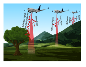
There are two types of LiDAR systems, airborne and terrestrial LiDAR. Airborne LiDAR originated and has become one of the common remote-sensing methods available. It’s even installed on helicopters and airplanes, sending light as pulsed lasers to the ground. The pulses hit the ground and returns to the sensor. Then, the system measures how long the light takes to return. Based on the return time, LiDAR measures the distance.
A LiDAR system can generate a precise three-dimensional map detailing the earth’s shape and surface using distance measurements, GPS data, and/or other data recorded by the airborne system.
Remote sensing uses two types of LiDAR systems, topographic and bathymetric. Topographic LiDAR uses an infrared laser to map the earth, and bathymetric LiDAR uses a water-penetrating green light to map the seabed floor and riverbed surfaces.
Airborne LiDAR is used for surface mapping of both natural and artificial structures. For example, it’s used to map geology and the earth’s surface and shorelines to generate digital elevation models or for land monitoring, city planning, and even natural disaster planning (to assess floods, landslides, tsunamis, etc.). It’s also commonly used to survey and monitor vegetation, agriculture, forestry, rivers, watersheds, and for archeology research.
LiDAR can also measure certain gases and particles in the atmosphere. In this way, it’s also sometimes used for climate monitoring and meteorology.
How LiDAR works
As LiDAR is a ranging device, the laser light, sensor, and GPS are its most important components. The distance between objects in a given space is recorded by measuring the time lapse between the transmitted and back-scattered light pulses. The system often uses a scan mirror or multiple beams of laser light to scan the target area.
An ideal laser beam wavelength is used to generate digital surface models or digital elevation models — one that’s safe for human eyes, but that does not get absorbed by atmospheric gases. These systems typically transmit about 160,000 laser pulses per second, scanning each meter pixel with about 15 pulses.
As an airplane moves, for example, the LiDAR system scans the ground surface from side to side. It scans through a span of 1~5Km area. Most of the laser pulses are transmitted at the ground at an angle and the others are directed below the system.
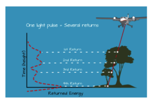
The transmitted pulses are then reflected from the ground or other objects. It has the same intensity if it’s reflected from the ground or the peak of a canopy. But if the laser beam hits the branches of a tree or the edges of a building, it’s reflected multiple times before being received by the sensor. The scattered laser beams return with lower intensity. In such cases, multiple reflections (i.e., the 1st, 2nd, 3rd returns, and so on) are recorded from a single laser pulse.
 A LiDAR system records several data points simultaneously, including the:
- Light intensity of the detected pulses
- X, Y, and Z location through GPS
- Orientation of an object (like the plane in the sky) with the help of an internal measurement unit.
As objects like trees and buildings on the ground scatter and reflect laser beams differently and at different intensities, LiDAR uses these differences to accurately and precisely map the ground surface, objects on the ground, and the distance with them.
The transmission and detection of the beams are controlled by software. The airborne LiDAR systems typically have a resolution of 40 cm horizontally and 15 cm vertically.
For climate monitoring and meteorology, LiDAR systems use specific wavelengths scattered, absorbed, or re-emitted by the molecules and particles in the atmosphere. By measuring the concentration of rain droplets, for instance, LiDAR systems can predict the distance of a storm or estimate predicted rainfall. In many meteorological systems, LiDAR systems incorporate the Doppler effect to measure the velocity of atmospheric wind.
 LiDAR uses scanning technology and, for this reason, works well in advanced vehicles. LiDAR can create a 3D model of the surrounding driving conditions even as the scene (traffic, construction, pedestrians, etc.) changes. With the Doppler technique, it can also be used to estimate the velocity of other vehicles.
LiDAR is similar to but different from radar and sonar. Radar uses radio frequencies, and sonar uses sound waves to scan the environment. LiDAR uses LASER beams.
LiDAR data
LiDAR systems record the distribution of a light waveform and light intensity. There can be two ways a light waveform is recorded — as a discrete return or full waveform.
- In a discrete return, peaks or other prominent objects are recorded as points in the waveform curve. These discrete points are called returns and are recorded on a scale 1~4 or more.
- In a full waveform, continuous distributions of the light waveform are recorded instead of discrete points. Full waveform LiDAR records the most information, so it’s more complex and involves more computational data to process.
Regardless of the recording method, LiDAR data is often also processed using discrete points, known as “point classification.” It’s made available as a collection of points called LiDAR point cloud, which may be available in .LAZ or .LAS format files.
In the LiDAR point cloud, the data attributes are described by metadata. These attributes include the X and Y locations, elevation value (Z), and the value of the recorded light intensity. There may be additional data like GPS and orientation. The point cloud is often processed to derive classification. The classification could be “ground” or “no ground,” “ground” or “vegetation,” or classification in buildings and other infrastructure.
The airborne LiDAR is mainly used to create high-resolution digital elevation models. It creates digital surface models to record the elevation of buildings, trees, the ground, and other structures. The canopy height models are derived by subtracting the ground elevation from the elevation of the trees, buildings, or other objects.
These models are used to predict the true height of topographic features from the earth. LiDAR may also be used to record vertical forest structures, such as to identify specific tree species.
Apart from point classification, LiDAR data can be used as a continuous record of light intensity. In this type of LiDAR data, the reflective percentages of the returned light waveform are recorded. The data is then used by object-based image classification or image classification.
Terrestrial LiDAR
Terrestrial LiDAR systems are generally installed on moving vehicles. These systems create three-dimensional models of roadways, infrastructure, buildings, and highways.
Portable LiDAR systems are used for architectural scans to create models of the interior and exterior of buildings. Terrestrial LiDAR systems include two types, static and mobile LiDAR.
Applications of LiDAR
Some of the popular applications of LiDAR are described below.
1. Mapping: LiDAR creates three-dimensional models of the earth’s surface. These models may be digital surface models or digital elevation models.
2. Oceanography: LiDAR is actively used to scan shorelines and sea surfaces, measuring the exact depth of the ocean. It can detect sealife, lost ships, or biomass in the sea.
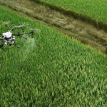
3. Agriculture: Remote sensing is the main application of a LiDAR system and can monitor crop yields, seed dispersion, and crop scouting for farmland.
4. Archeology: Mobile LiDAR systems survey archeological structures and create three-dimensional models to conserve them digitally.
5. Military: LiDAR systems are commonly deployed in border areas to detect trespassing.
6. Architecture: Mobile LiDAR systems can survey the interior and exterior of buildings and create 3D models. They’re commonly used to develop floor plans and interior designs.
7. Space: LiDAR systems support the safe landing of lunar vehicles.
8. Natural disasters: LiDAR systems estimate the distance and speed of storms and map flood risks, coastal erosions, and carbon stock in forests.
9. Automobiles: Small, low-range LIDAR is used in ADAS systems to scan a dynamic scene and navigate autonomous vehicles.
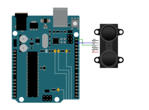
Using LiDAR with Arduino
LiDAR is something you can try for yourself. Check out this tutorial to learn how LiDAR systems work with Arduino.
You may also like:


Filed Under: Arduino, ARM., Tech Articles

Questions related to this article?
👉Ask and discuss on EDAboard.com and Electro-Tech-Online.com forums.
Tell Us What You Think!!
You must be logged in to post a comment.